Mapping Histories of Public Space
Can we develop a methodology to identify and categorise public spaces? As we move in the city do we understand the changing spaces through which we move and does this have implications for the future?
As we move through the city, it is not always clear whether the spaces through which we pass are public or private, but this issue impacts upon the daily lives of citizens. Public space is a rather inchoate concept and understandings have changed over time. Today, public space is best understood as local authority owned land, particularly parks, libraries or community centres. Open spaces held privately might impose different regulations than those held by public bodies, and might be subject to different accountability. With the effects of austerity on local authorities and repeated Government pressures to sell off “unproductive” public land there is a current swathe of privatisation that it is important to record. This has been noted in Bristol (eg. Cabot Circus) and remains an issue of citizen concern.
What did the project involve?
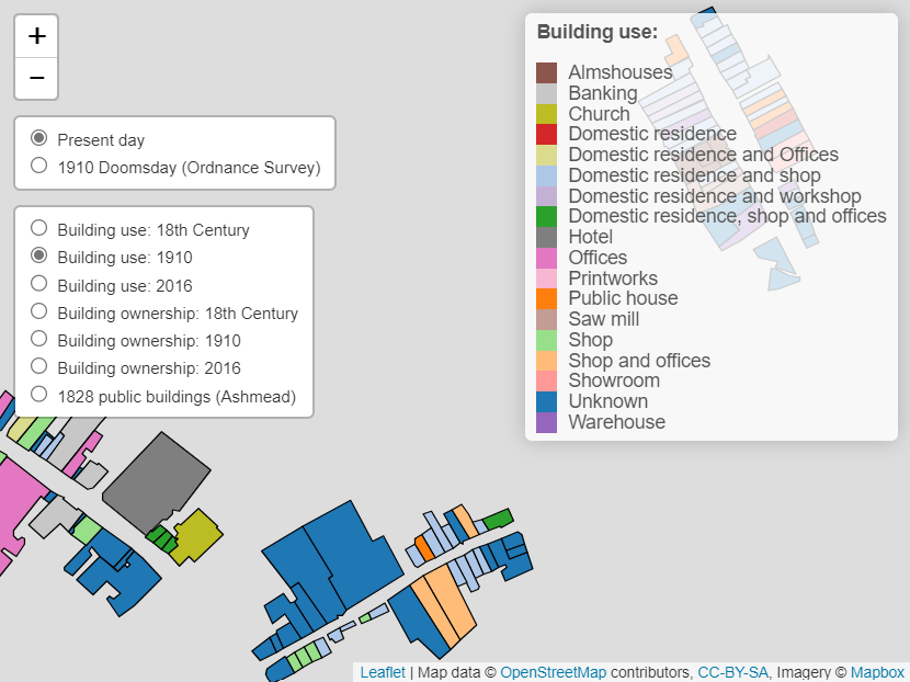
The project placed the issue of public space within the historical context by digitally mapping changes to public space over three centuries. Drawing upon sources held by Bristol Record Office and elsewhere it will quantify changes to the amount of public space over time, explore regulations governing behaviour within public spaces, and examine how and why changes occurred.
This experimental, trans-historical project brought together historical investigations with legal and policy explanations of the relationship between public space and property rights over time. The project has four main aims:
- to gain a richer understanding of how we understand and use public spaces;
- to augment existing mapping resources;
- to develop a methodology of using historical geo-referenced materials to inform scholarship;
- to provide a resources, in the form of map layers and a website, for Bristol citizens and others interested in questions of public space in the city.
The project began with a meeting in the Wills Building in which the team discussed the themes they’d like to explore and how to share the Public Space work with other organisations, like Bristol Records Office and the City Council.
The team identified a lot of valuable work done in mapping Bristol through projects like Know Your Place which this project sought to build on and enhance.
In the meeting, alongside the research team, there was Julian Warren (Bristol Records Office), Pete Insole (Bristol City Council), and Andrew Ventham (Bristol City Council, GIS).
Who are the team and what do they bring?
- Antonia Layard (Law, University of Bristol) is a researcher in law and geography where she explores how law, legality and maps construct space, place and ‘the local’. She will bring expertise on property law and an extensive understanding of public space in the UK today.
- Alex Craven is a freelance historian, based in Bristol, who has a particular specialism in early modern (1500-1800) English local history. He will bring expertise in archival research as well as extensive historical knowledge of urban development in Bristol and other cities.
- Kev Kirkland (Data Unity) is the founder of Data Unity and a Studio Resident at the Pervasive Media Studio at the Watershed. He brings expertise in data visualisation, Open Data and Open Source with a long track record in helping people explore, visualise and share data. Data Unity uses the latest ideas from Big Data, real-time data and visualisation methodologies to find ways to make data more meaningful and accessible.
What were the results?
The project culminated in the creation of Public Space Bristol which was launched in the Wills Building on 13th October 2016 as part of the Brigstow Institute launch event. The mapping website allows users to see and explore the changing use and ownership of Bristol spaces.